


Registration is Closed
$60 Full Meeting: MAGIP Members
$75 Full Meeting: Non-MAGIP Members
FREE Workshops Go the Workshop page for more information.
The Spring Meeting will be a Provider of Renewal Units for Professional Development under the Office of Public Instruction!
Download the 2013 flyer in printable PDF format: SaveTheDateFlyer_SpringMeeting2013.pdf
The ArcGIS Fundamentals I & II workshops are free to anyone! (You do not need to be registered for the Spring Meeting to attend but you do need to register for the workshops to reserve your spot.)
All other workshops are FREE with Spring Meeting registration. (Register for the workshops to reserve your spot.)
Van Shelhamer, who was scheduled to teach the two intro GIS classes passed away on April 12. Esri has graciously offered to provide an additional trainer for these workshops.
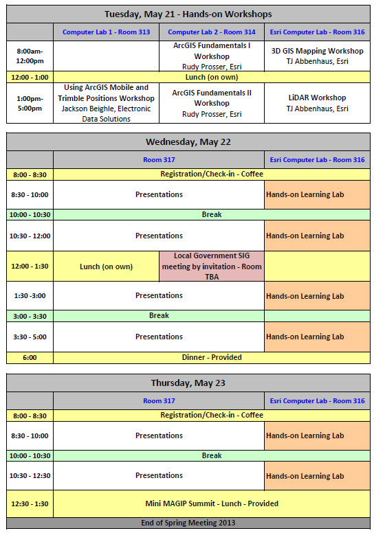
Tuesday, May 21
3D GIS Mapping Hands-on lab 8 AM - Noon FREE LiDAR Workshop Hands-on lab 1 PM - 5 PM FREE ArcGIS Fundamentals I Hands-on lab 8 AM - Noon FREE ArcGIS Fundamentals II Hands-on lab 1 PM - 5 PM FREE Using ArcGIS Mobile and Trimble Positions Hands-on lab 1 PM - 5 PM FREE
Wednesday & Thursday, May 22 & 23
Esri Hand-on Learning Lab Hands-on lab Open all day Free to conference attendees
Full conference registration does not include workshop costs, these are extra.
Esri 3D GIS Mapping
Date/Time: Tuesday, May 21, 8 AM - Noon
Cost: FREE
Format: Hands-on lab, laptops will be provided and maximum enrollment is 30 participants (two per laptop).
Instructor: TJ Abbenhaus, Solution Engineer with EsriThe hands-on Esri 3D GIS Mapping Lab will introduce users to modern workflows for managing, producing, and sharing of 3D information using onsite enterprise architecture or cloud architecture.
Attendees will learn how to bring GIS workflows that extend 2D data into 3D data incorporating remote sensing, lidar and aerial imagery. Using all of these sources of information you will be shown how ArcGIS is used for accurate 3D visualization and spatial analysis.
Lastly attendees will learn how to reach a wide audience with 3D information using the internet based ArcGIS web scenes and ArcGIS online. It will be shown how the derived information can be distributed as a support tool for critical decisions.
Date/Time: Tuesday, May 21, 1pm - 5 PM
Cost: FREE
Format: Hands-on lab, laptops will be provided and maximum enrollment is 30 participants (two per laptop).
Instructor: TJ Abbenhaus, Solution Engineer with EsriThis seminar will cover managing and using lidar point cloud data with ArcGIS 10.1. By attending these sessions GIS users will be able to learn how to manage Lidar data, use ArcGIS for 2D/3D visualization and analysis, as well as share their Lidar data through webservices.
Attendees will learn a complete Lidar data management strategy, including: how to catalog their data; when to use LAS Datasets, terrain Datasets, and Mosaic Datasets; what analytical options are available for Lidar; how to fuse Lidar data with other spatial and operational layers; and techniques for making Lidar data more accessible.
By utilizing the ArcGIS platform, organizations will be better able to support informed decision making by providing simple and timely access to your Lidar and Imagery.
Date/Time: Tuesday, May 21, 8 AM - Noon
Cost: FREE
Format: Hands-on lab, laptops will be provided and maximum enrollment is 30 participants (two per laptop).
Instructor: Rudy Prosser, Esri Instructor, CompTIA CTT+ CertifiedThis four hour hands-on workshop is designed for individuals who are new to GIS (no prior GIS education or workplace experience with GIS). This workshop will be based on Esri’s web class: Getting started with GIS (For ArcGIS 10.1). Participants will use online resources to quickly create a GIS map; describe two common data models used to represent real-world objects and phenomena in a GIS; evaluate geographic data for use in a GIS mapping project; explore a GIS map and access information about map features; visually analyze feature relationships and patterns on a GIS map; create queries to find and select features that meet specific criteria; and prepare a GIS map to share information and present analysis results.
Date/Time: Tuesday, May 21, 1pm - 5 PM
This four hour hands-on workshop will expand on concepts taught in ArcGIS Fundamental I and will help users gain a deeper understanding of ArcGIS editing and analysis. This workshop will be based on Esri’s web classes: Editing in ArcGIS Desktop 10 and Solving Spatial Problems using ArcGIS 10.1. Participants will edit with feature templates; work within the snapping environment and learn to follow new editing workflows. Participants will also learn to follow steps in the geographic approach to solve a spatial problem; evaluate and prepare data for an analysis project; select appropriate tools to combine data and obtain new output data needed for an analysis; solve a site-selection problem by finding optimal locations based on a set of spatial criteria; share your analysis results with other ArcGIS users.
Cost: FREE
Format: Hands-on lab, laptops will be provided and maximum enrollment is 30 participants (two per laptop).
Instructor: Rudy Prosser, Esri Instructor, CompTIA CTT+ Certified
Using ArcGIS Mobile and Trimble Positions with ArcGIS 10.1
Date/Time: Tuesday, May 21, 1pm - 5 PM
Cost: FREE
Format: Hands-on lab, laptops will be provided and maximum enrollment is 30 participants (two per laptop).
Instructor: Jackson Beighle from Electronic Data SolutionsEnsure your GIS is populated with only the best quality data. When you work with Esri ArcGIS for Windows Mobile® 3.1 or Esri ArcPad, you can depend on Trimble® handheld GNSS and Trimble Positions™ software to deliver the accuracy you need and a streamlined workflow to make the total solution fast and seamless.
Extend your GIS beyond the office to deploy intuitive and productive mobile data collection for accurate, up-to-date data across your organization. With the release of the Trimble® Positions™ Mobile extension you now have access to all the advantages of the Trimble Positions software within ArcGIS Mobile.
An extension for Esri ArcGIS Mobile field software, the Trimble Positions Mobile extension integrates ArcGIS Mobile workflows into the Positions software suite as an alternative to Trimble GPScorrect™ extension / GPS Analyst™ extension workflows.
As part of the workshop, you will have access to a range of Trimble GPS handhelds loaded with Esri ArcGIS Mobile together with the Trimble Positions ArcGIS extension and sample data and receive a full demonstration of the workflow from field to office.
Date/Time: Wednesday & Thursday, May 22 & 23, open all day
Cost: FREE to conference attendees
Format: Hands-on learning lab, laptops will be provided on a first-come, first-served. 15 participants at a time.
Presented by EsriExplore Esri software offerings and get free training at the Hands-on Learning Lab. The Learning Lab offers self-paced training sessions (approximately 45 minutes each) featuring a recorded demo and an interactive exercise. No registration required, first-come, first-served. Esri instructors are available to answer your questions. Lesson topics for Version 10.1 include:
- Basics of the Geodatabase Model
- Creating a Map in ArcGIS for Desktop
- Designing Web Applications with ArcGIS for Server
- Editing with ArcGIS for Desktop
- Geocoding with ArcGIS for Desktop
- Getting Started with Business Analyst Online and Community Analyst
- Introduction to ArcGIS for Desktop
- Introduction to ArcGIS for Server
- Introduction to ArcGIS Network Analyst
- Introduction to ArcGIS Spatial Analyst
- Introduction to Geometric Networks for Utilities Applications
- Introduction to Geoprocessing Using Python
- Introduction to Linear Referencing
- Introduction to Versioned Editing
- Sharing Data with the Community Maps Program
- Sharing Maps and Tools Using ArcGIS Online
- Spatial Statistics for Public Health
- What's New at Version 10.0 and 10.1
- Working with CAD in ArcGIS for Desktop
If you are part of a local government, we want to invite you to join us for this meeting during the Spring Meeting. This Special Interest Group exists to connect and support those users facing the specific needs and challenges of local government today.May 22, 2013 - 12:00 - 1:15
SIGs provide valuable feedback to the MAGIP Board that may affect policy, standards and future work plans.
On behalf of MAGIP and the Local Government SIG, we hope you can join us for this discussion in Miles City!
Remote access is available Conference registration is NOT required for the SIG meeting.
RSVP is required by May 15 Lunch provided
Please contact Allen Armstrong to RSVP and for more information allen.armstrong@gallatin.mt.gov


