|
2018 Big Sky GeoCon

Gold Sponsors
 |
|
 |
Silver Sponsors
| |
||
|
|
 |

|
Conference Break Sponsor
|
Student Scholarship Sponsor  |
Raffle Item Sponsor |
|
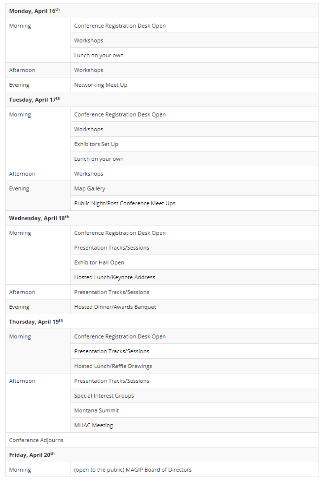
Schedule Overview
Attendee Registration Fees
Cancellation Policy: Refunds for cancellations after March 30, 2018 will not be issued
Exhibitor/Sponsor Opportunities
Exhibitor Prospectus
Workshops
Keynote Presenter
The Big Sky GeoCon Planning Committee is pleased to announce Historian Dr. Ellen Baumler as keynote speaker! Keeping in line with our theme (More Than Maps), Ellen will provide a unique perspective on how maps tell history, keep history alive, and how they really are ‘More Than Just Maps’!
Ellen was also a contributor to the Helena Walking App. The app provides an interactive way to explore and learn about Helena’s history and architecture. Ellen wrote the content associated to the images within the app! 
U.S. Census PresentationsThe Geographic Update Partnership Software (GUPS) is a free GIS software provided by the U.S. Census Bureau to our geographic program partners. GUPS is used to collect spatial information such as boundaries and linear features in geographic programs such as the Block Boundary Suggestion Project, The Voting District Project, the Boundary and Annexation Survey, the Local Update of Census Addresses (LUCA), the School District Boundary Review Program, and the Participant Statistical Areas Program. It is also used to collect address information in LUCA. During this workshop you will learn the basic functionality of GUPS that crosses over all programs, as well as GUPS tools developed for the unique needs of each program. Presentation Slides Assistant Chief Census Redistricting & Voting Rights Data Office Decennial Census Programs Directorate U.S. Census Bureau MSDI Administrative Boundaries and U. S. Census Programs Update The Montana State Library is the steward of the Montana Spatial Data Infrastructure (MSDI) Administrative Boundaries which is comprised of: Incorporated Cities and Towns, Reservations, School Districts, County Boundaries, Tax Increment Financing Districts, Weed Management Districts, and the State Boundary. This presentation will provide an update on the U. S. Census Boundaries and Annexation Survey (BAS) and School District Review Program (SDRP) as well as database schema changes and web service updates. MSDI Administrative Boundaries Theme Steward BAS State Certification Officer for Montana School District Mapping Coordinator for Montana Montana State Library LUCA trouble-shooting presentation An overview of issues and tips on how to conduct LUCA work in-house. Attend this presentation to hear about ways to process your address list and how to compare it with the Census Bureau address list. This presentation is designed for those program participants who have received materials from the Census Bureau and need guidance on how to proceed with LUCA review. Jim Castagneri Geographic Coordinator U.S. Census Bureau - Denver For each decennial Census, the U.S. Census Bureau delineates new Census tabulation blocks. Census Blocks are the smallest geographic unit used by the Census Bureau for tabulating decennial census data. The Census Bureau will delineate the 2020 Census Blocks in mid-2020. This presentation will explain how the Census Bureau determines what visible features (such as roads, streams, railroads and transmission lines), and non-visible features (including city, township, school district, and county boundaries) are used to bound the new blocks. The presentation will also highlight the importance of feature and boundary accuracy in its Master Address File/Topological Integrated Geographic Encoding and Referencing (MAF/TIGER) System for delineating blocks, and how local and state governments can influence block delineation by providing accurate boundary and feature information. Assistant Chief Census Redistricting & Voting Rights Data Office Decennial Census Programs Directorate U.S. Census Bureau Public Law 94-171 require the U.S. Census Bureau to work with states in a non-partisan manner to identify geographic areas for which population tabulations are needed for legislative redistricting, and to deliver those tabulations to the states no later than one year from Census Day (April 1, 2021). This presentation will explore how the Census Bureau meets the requirements of P.L. 94-171 through the Redistricting Data Program. The Census Bureau’s design plans for the 2020 Census Prototype Redistricting Data File design will be discussed with some explanation on how the states use these data for their legislative redistricting. Assistant Chief Census Redistricting & Voting Rights Data Office Decennial Census Programs Directorate U.S. Census Bureau Do you know where to look for the data you need? This presentation will review the Data Tools Tab for accessing Census data through products and tools including data visualizations, mobile apps, interactive web apps and other software. Data Dissemination Specialist Data Dissemination Branch Customer Liaison & Marketing Services U.S. Census Bureau Preparing Data Tables for Tableau In this session data users will see how Census Bureau data tables can be uploaded into a public mapping tool for combining data from multiple resources for visual dynamics. Data Dissemination Specialist Data Dissemination Branch Customer Liaison & Marketing Services U.S. Census Bureau
For additional information please contact MAGIP
|
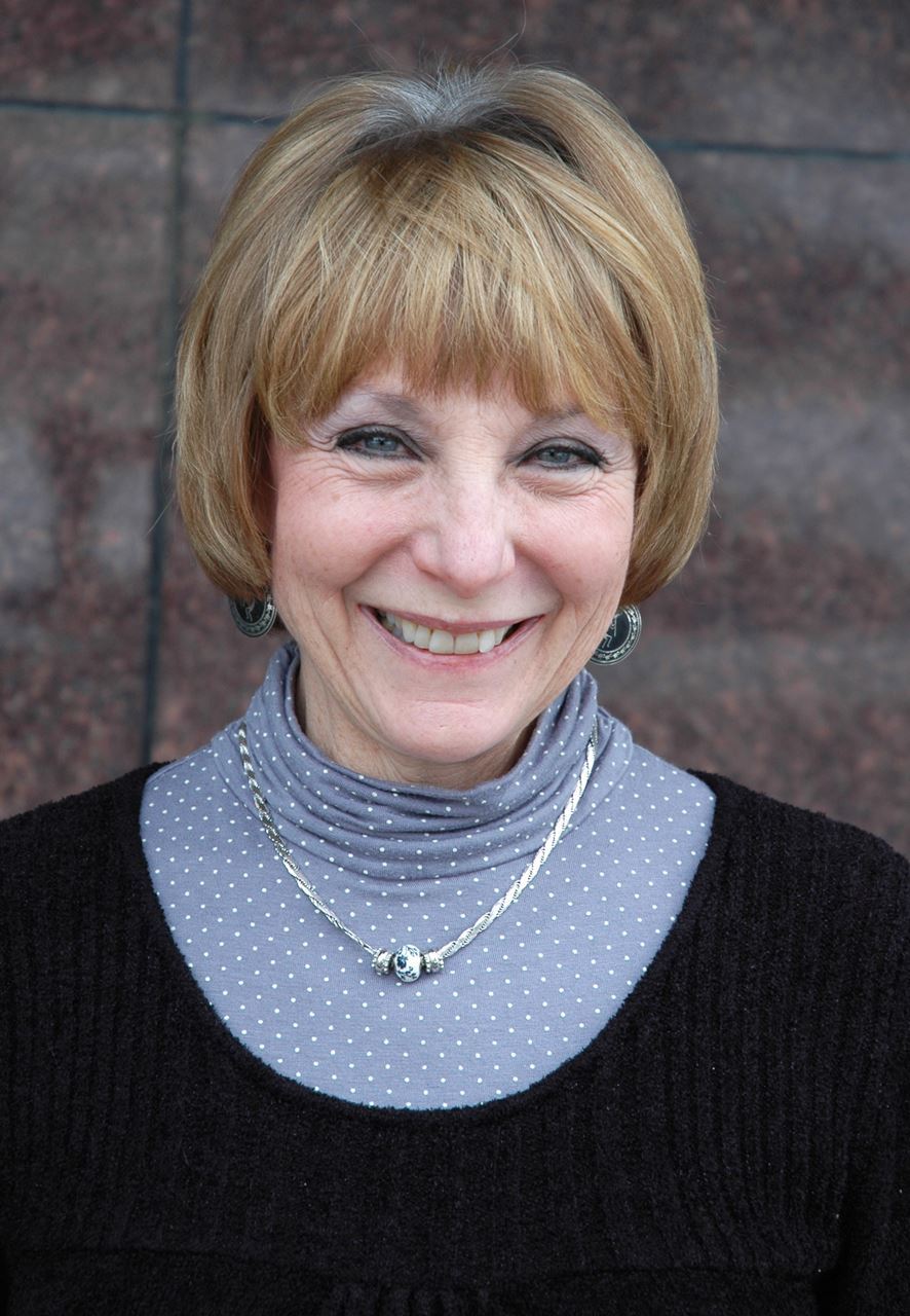 Ellen Baumler has been the interpretive historian at the Montana Historical Society since 1992. She received her PhD in English, classics, and history from the University of Kansas. She is a longtime member of the Humanities Montana Speakers Bureau and a 2011 recipient of the Governor’s Award for the Humanities. She was the co-curator of the society’s recent award-winning Chinese exhibit, “Forgotten Pioneers.” Ellen has composed hundreds of signs for Montana’s historic sites, created walking tours for diverse audiences, and taught in classrooms across Montana. A popular speaker and storyteller, she is an award-winning author of 11 books and dozens of articles on historical topics. Ellen especially delights in sharing Helena’s lesser known history with audiences of all ages.