 |

2010 MAGIP Nominees
MAGIP Elections will be held from May 3 - June 1, 2010. All members in good standing will receive an e-mail from the Board with a ballot and directions on how to vote. Members can only vote once. Please contact the Board with any questions on the MAGIP 2010 Elections: Board of Directors
Ask a nominee a question in our General Discussion Forum: Click Here
Vice President:
Danielle Price
My name is Danielle Price and I work for the USDA Farm Service Agency as their GIS Coordinator/Specialist. We are working in an SDE environment and soon to be moving to a Citirx environment. I hope to further enhance the communication in the GIS community through MAGIP.Wendy Thingelstad
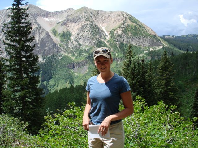
 My name is Wendy Thingelstad and I am a graduate from the University of Montana where I earned a major in both Environmental Studies and in GIS with a minor in Geology. Being a Montana girl, I love all things that require interaction with nature and require ton of effort such as hiking, climbing, running, fishing, camping, skiing and shoeing. Building a sense of community is one of my strong suits, as I am usually either putting together a group effort of some sort or actively participating in one. Currently, I am proud to be on the Education committee and am VERY excited to be a part of putting together the Mentoring Program with Diane and the rest of the sub committee. I have not only lived in Montana for most of my life, but have also worked in Montana’s GIS community under several different types of GIS software and environments which I believe gives me an insight that helps me understand a very broad range of GIS related issues.
Member-at-Large (2 positions available):
Tara Chesley-Preston
 Tara Chesley-Preston lives in Bozeman, Montana, moving here from Colorado in 2007. In 2005 she graduated magna cum laude with an undergraduate degree in Geology from the University of Colorado, Boulder. After graduating, she spent two years working at INSTAAR in their stable isotope lab doing paleoclimate reconstruction work with ice cores. Tara is currently finishing her master's degree in Earth Sciences at Montana State University (MSU), which involves quantifying the relationship between natural avalanches and wind direction, wind speed, and new snow. She also works for the United States Geological Survey (USGS) as a spatial analysis and GIS specialist studying brine water contamination from oil and gas development in the Williston Basin and the affects on the Prairie Pothole Region. In addition to her graduate and USGS work she has also extended her geospatial background through her teaching assistance with Stuart Challender at MSU working as the lab TA for all three undergraduate GIS courses. Although the majority of Tara’s GIS experience has been in the field of physical geography, she also worked on a historical geography project with Dr. Billy Smith at MSU reconstructing 1790 Philadelphia. Tara had her first direct experience with MAGIP through her work coordinating a mini-conference for the 2010 Intermountain GIS Conference, focusing on the use of GIS in snow and avalanche sciences.
Tara is very excited about her nomination to the MAGIP Board of Directors. She is really looking forward to the opportunity to present new ideas to the group from the perspective of an individual beginning a career in the geospatial sciences. In particular, Tara would like to share her experiences in assisting undergraduate students in the development of their geospatial sciences knowledge and skill set. In the fall of 2009 Tara was selected to participate in a course specializing in communicating science to the public. With the help of this course and her teaching experience she has learned many techniques and skills that she feels could be applied directly to the work done through MAGIP benefiting people who are new to the geospatial sciences.
Jason Danielson
 Jason Danielson is the GIS Database Analyst for the City of Helena and Lewis and Clark County GIS Services Department. His duties include maintaining the City/County SDE Enterprise data, assisting in data analysis and map production, and providing GIS support for any City/County Department utilizing GIS. His role also includes updating and maintaining the Lewis and Clark County Interactive Mapping websites (www.helenamontanamaps.org). He holds a Bachelor of Science degree in geography from the University of North Dakota (2000), and his previous GIS experiences include working for Montana’s Department of Revenue, Bullberry Systems Inc., and AgriData, Inc. He has been a MAGIP member for many years, and currently serves as a member of the MAGIP Technical Committee and MAGIP Mentoring Subcommittee.
Jason hopes to contribute his insight on current and anticipated projects throughout our GIS community. He believes that sharing ideas and information amongst fellow GIS professionals is an important way to learn more about GIS and its potential. His vision for MAGIP is to promote a GIS community that encourages cooperation and communication with other entities and fellow users.
Jon Henderson
 Hello everyone! My name is Jon Henderson and I am the GIS Manager for the City of Bozeman. I have enjoyed a wonderful opportunity in spearheading our local government department over ten years ago, helping to bring the city into a new age of managing public assets with GIS. We are heavy into using data in the field to manage infrastructure (water/sewer/streets/trees/etc.) as well as providing valuable web services to the public. Prior to joining the City of Bozeman, I was the GIS Coordinator for Laidlaw Transit from 1995-2000 (one of North America's leading transit providers). I graduated from the University of Montana with a Bachelor of Arts (Geology) in 1997. I have been a member of the Montana Association of GIS Professionals (formerly MLGGC) since 2000 and also a certified GIS Professional (GISP). I look forward to providing valuable experience and energy to MAGIP as we build on prior successes. Thank you for your consideration.
Ricki Ann Ketterling
 Hello, my name is Ricki Ann Ketterling. Over the past nine years I have been working with GIS data at Electrical Cooperatives, Engineering firms and now for the State of Montana at the Department of Environmental Quality.
Last year I became certified as a GIS Professional (GISP). My experiences include: Arc Info, Arc Editor, Arc View, SDE/SQL, GIS 3rd party network analysis software and an extensive CAD background. I have worked in the field collecting data with both enterprise grade and survey grade GPS equipment. I also have been working with LIDAR data and conversion of AutoCAD drawings to GIS software. Currently I have been working developing geodatabase repositories for The Clark Fork River, Silver Bow Creek and Montana Pole remediation projects.
I have a Bachelor of Arts in Communication (2002) and an Associate of Applied Science in Design Drafting Technology (2000) from Montana State University Billings. I am also a member of MSUB College of Technology Drafting and Design Advisory Board.
I have been a member of the Montana Association of Geographic Information Professionals (MAGIP) for about three years and would like to be a more involved member.
John Lucotch
I am currently a GIS Analyst, Web Developer, and TeraGrid Campus Champion for the University of Montana's Flathead Biological Station. My current work includes development of the Riverscape Analysis Project (http://rap.ntsg.umt.edu/), which is a geospatial database of riverine landscape features in the North Pacific. Before my position at the Flathead Lake Biological Station, I was a GIS Intern at the Montana Department of Natural Resources and Conservation.
I have experience in ArcGIS, Open Source GIS and Python Programming. My specialties include web development using ArcGIS Server and integrating those web services with Python. I also have worked extensively on implementing GIS with the Google Maps API.
My vision for MAGIP is continuing to promote the advancement of geographical information systems throughout the State of Montana.Chris Stump
Hello all! My name is Chris Stump and have utilized geospatial technologies for a broad range of applications over the past seven years. I graduated with a Bachelor of Science in Physical Geography from Montana State University in 2003, and was granted an internship with the Park County Rural Addressing department collecting GPS points and associated photographs of properties throughout the Livingston area to aid in tax appraisal that year. I then worked as a GIS Technician/Field Crew leader for Hyperspectives/Yellowstone Ecological Research Center (YERC) in Bozeman. At YERC I created and documented a geoprocessing routine to map coyote/wolf interactions, prepared LIDAR and ASTER imagery for analysis, and collected slope, elevation, and aspect measurement via Total Laser and Compass throughout the northern range of Yellowstone.
Realizing I needed to further my education and graduate in less than ten years, I left Bozeman and Bridger Bowl to attend graduate school at the University of Montana (UM). While living in Missoula, I worked for the USDA Forest Service as a Cartographic Technician specializing in generating and editing forest visitor maps, and served as a RAVAR Analyst (Rapid Assessment of Values at Risk) for the Rocky Mountain Research Station. While finishing my master’s thesis, I started working as the GIS Developer for the Montana Department of Environmental Quality (DEQ). My wide span of responsibilities at DEQ includes geoprocessing and workflow automation for data entry, GPS field collection, spatial analyses, database replication, and ArcSDE/server management.
This past fall I graduated from UM, Department of Geography, with a Masters of Science in Geography and GIS under the superb guidance of Anna Klene. My graduate work involved using pollen data collected from sediment cores distributed throughout western North America to map and track vegetation and climate trends over the past 10,000 years via direct and indirect statistical ordination techniques coupled with landscape trajectory analysis.
I want to be more involved in MAGIP and the Montana regional GIS community because I believe our field is extremely important and influential in educating everyone of the economic, cultural, ecological, and societal condition and aspects of our great state and the surrounding area. Although many people are not directly aware, geographic principles and practices are being utilized to manage and present all types of information, and I want to have an influential hand in ensuring that information is portrayed in the most accurate and positive light possible. Lastly, as a native Montanan, I love and very actively pursue hunting, fishing, rafting, backpacking, biking, running, and skiing to their fullest. Thank you for your consideration.